|
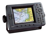
GPSMAP 198C Sounder |
Garmin |
Marine GPS |
2005 |
|
Description: Marine GPS Type: Chartplotter, Sonor - Screen Size: 5" - Screen Type: TFT LCD - Resolution: 234x320 - Transducer Type: Dual Frequency |

|
GPSMAP 6008 |
Garmin |
Marine GPS |
2010 |
|
Description: Marine GPS Type: Chartplotter - Screen Size: 8.4" - Resolution: 640x480 - Memory Format (MSD): SD - GPS Navigation Features: External Antenna, Tide Table - I/O Interfaces: NMEA |

|
GPSMAP 620 |
Garmin |
Marine GPS |
2009 |
|
Description: Marine GPS Type: Chartplotter - Screen Size: 5.2" - Resolution: 800x480 - Memory Format (MSD): Internal - GPS Navigation Features: 2D/3D Mapping, Built-In Antenna, Automatic Rerouting, Track Log, Tide Table, Touchscreen, Sunset/Sunrise Calculator, Voice Guidance - Preloaded Map Coverage: Canada, Puerto Rico, United States - # of Waypoints: 1500 - Battery Type: Li-Ion |

|
GPSMAP 178C Sounder (Internal Antenna/Single Frequency Transducer Version) |
Garmin |
Marine GPS |
2004 |
|
Description: Marine GPS Type: Chartplotter, Sonor - Screen Size: 4.5" - Screen Type: LCD - GPS Navigation Features: Built-In Antenna, Tide Table - Preloaded Map Coverage: Australia, Europe, South America, United States - Transducer Type: Single Frequency - Transducer Frequency: 200 MHz - Transducer Wattage: 400 |

|
Echo 501 |
Garmin |
Marine GPS |
2014 |
|
Description: Non Transducer Model. Marine GPS Type: Fishfinder - Screen Size: 5" - Screen Type: LCD - Resolution: 234x320 - GPS Navigation Features: Track Log, Fish Identifier, Thermometer, Split Screen - Depth Range (Feet): 2300 |
|
|
EchoMAP CHIRP 93sv |
Garmin |
Marine GPS |
2015 |
|
Description: Marine GPS Type: Chartplotter, Fishfinder - Screen Size: 9" - Screen Type: LCD - Resolution: 800x480 - Memory Format (MSD): Micro SD - GPS Navigation Features: Tide Table - Preloaded Map Coverage: United States - Depth Range (Feet): 2300 - Transducer Type: Dual Beam, Dual Frequency - Transducer Frequency: 260/455/800 kHz - I/O Interfaces: NMEA |

|
Fishfinder 100 |
Garmin |
Marine GPS |
1999 |
|
Description: Non Transducer Model. Marine GPS Type: Sonor - Screen Size: 2.5" - Screen Type: LCD - Resolution: 160x100 - Memory Format (MSD): Internal - GPS Navigation Features: Language |
|
|
GPSMAP 220 |
Garmin |
Marine GPS |
1994 |
|
Description: Marine GPS Type: Chartplotter - Screen Type: TFT LCD - # of Waypoints: 500 |

|
Echo 300c |
Garmin |
Marine GPS |
2011 |
|
Description: Marine GPS Type: Fishfinder - Screen Size: 3.5" - Screen Type: FSTN - Resolution: 240x320, 320x240 - GPS Navigation Features: Sonor Alarm, Track Log, Depth Alarm, Whiteline, Fish Identifier, Speed/Temp Sensor, Auto Zoom, Split Screen - Preloaded Map Coverage: United States (Coastal) - Depth Range (Feet): 1500 - Transducer Type: Dual Beam - Transducer Frequency: 77/200 kHz - Transducer Wattage: 300 |
|
|
Striker 4 |
Garmin |
Marine GPS |
2016 |
|
Description: Marine GPS Type: Fishfinder - Screen Size: 3.5" - Screen Type: LCD - Resolution: 480x320 - GPS Navigation Features: Split Screen, Thermometer, Fish Identifier - Depth Range (Feet): 1600 - Transducer Type: Dual Beam, Dual Frequency - Transducer Frequency: 50/200 kHz - Transducer Wattage: 200 |
|
|
Echo 201 |
Garmin |
Marine GPS |
2014 |
|
Description: Transducer Model. Marine GPS Type: Fishfinder - Screen Size: 5" - Screen Type: LCD - Resolution: 320x480 - GPS Navigation Features: Thermometer, Split Screen, Track Log, Fish Identifier - Depth Range (Feet): 1750 - Transducer Type: Dual Beam, Dual Frequency |

|
GPSMAP 3205 |
Garmin |
Marine GPS |
2006 |
|
Description: Marine GPS Type: Chartplotter - Screen Size: 5" - Screen Type: TFT LCD - Resolution: 234x320 - GPS Navigation Features: 2D/3D Mapping |
|
|
Echo 101 |
Garmin |
Marine GPS |
2014 |
|
Description: Marine GPS Type: Fishfinder - Screen Size: 4" - Screen Type: LCD - Resolution: 160x256 - GPS Navigation Features: Fish Identifier - Depth Range (Feet): 1600 - Transducer Frequency: 200 kHz |

|
GPSMAP 188 Sounder |
Garmin |
Marine GPS |
2001 |
|
Description: Non Transducer Model. Marine GPS Type: Chartplotter, Sonor - Screen Size: 5.5" - Screen Type: LCD - Resolution: 360x240 - GPS Navigation Features: External Antenna, Tide Table - Preloaded Map Coverage: Australia, Europe, South America, United States - Depth Range (Feet): 1500 |

|
GPSMAP 535 |
Garmin |
Marine GPS |
2006 |
|
Description: Marine GPS Type: Chartplotter - Screen Size: 5" - Resolution: 480x640, 640x480 - Memory Format (MSD): SD - GPS Navigation Features: Tide Table - Preloaded Map Coverage: Australia, Europe, South America, United States, United States (Lakes/Rivers) - # of Waypoints: 1500 |
|
|
GPSMAP 527 |
Garmin |
Marine GPS |
2012 |
|
Description: Marine GPS Type: Chartplotter - Screen Size: 5" - Screen Type: LCD - Resolution: 480x640 - Memory Format (MSD): Micro SD - GPS Navigation Features: Tide Table, Track Log - Preloaded Map Coverage: United States (Coastal) - # of Waypoints: 5000 - I/O Interfaces: NMEA |
|
|
GPS 120XL |
Garmin |
Marine GPS |
1997 |
|
Description: Marine GPS Type: Chartplotter - Screen Size: 4.3" - Screen Type: LCD - GPS Navigation Features: Track Log, Automatic Rerouting - # of Waypoints: 250 |
|
|
GPSMAP 922 |
Garmin |
Marine GPS |
2016 |
|
Description: Marine GPS Type: Chartplotter, Sonor - Screen Size: 9" - Screen Type: LCD - Resolution: 1024x600 - Memory Format (MSD): Micro SD - GPS Navigation Features: Touchscreen, Tide Table - Preloaded Map Coverage: United States (Coastal), United States (Lakes/Rivers) - Depth Range (Feet): 5000 - Transducer Type: Dual Beam, Dual Frequency - Transducer Frequency: 77/200 kHz - I/O Interfaces: NMEA, BNC |
|
|
EchoMAP Plus 72sv |
Garmin |
Marine GPS |
2018 |
|
Description: Transducer Model Marine GPS Type: Chartplotter - Screen Size: 7" - Screen Type: LCD - GPS Navigation Features: Track Log, Tide Table - Preloaded Map Coverage: United States (Coastal) - # of Waypoints: 5000 - Transducer Type: Dual Beam, Dual Frequency - Transducer Frequency: 50/200 kHz |

|
GPSMAP 2210 |
Garmin |
Marine GPS |
2006 |
|
Description: Marine GPS Type: Chartplotter - Screen Size: 10" - Screen Type: TFT LCD - GPS Navigation Features: 2D/3D Mapping |
|
|
GPSMAP 7408xsv |
Garmin |
Marine GPS |
2014 |
|
Description: Memory Format: SD - Marine GPS Type: Chartplotter, Sonor - Screen Size: 8" - Screen Type: LCD - Resolution: 1024x600 - GPS Navigation Features: Tide Table, Touchscreen - Depth Range (Feet): 5000 - Transducer Type: Dual Beam, Dual Frequency - Transducer Frequency: 50/200 kHz - I/O Interfaces: Composite, NMEA, DVI |

|
GPSMAP 172C |
Garmin |
Marine GPS |
2004 |
|
Description: Marine GPS Type: Chartplotter - Screen Size: 4.5" - Screen Type: TFT LCD - GPS Navigation Features: Tide Table, Built-In Antenna - Preloaded Map Coverage: United States - Transducer Frequency: 200 MHz |

|
GPSMAP 178 Sounder (External Antenna/Single Frequency Transducer Version) |
Garmin |
Marine GPS |
2004 |
|
Description: Marine GPS Type: Chartplotter, Sonor - Screen Size: 7.5" - Screen Type: LCD - GPS Navigation Features: External Antenna, Tide Table - Preloaded Map Coverage: Australia, Europe, South America, United States - Transducer Type: Dual Frequency - Transducer Wattage: 500 |

|
GPSMAP 2010 |
Garmin |
Marine GPS |
2001 |
|
Description: Marine GPS Type: Chartplotter - Screen Size: 9.4" - Screen Type: LCD - Resolution: 640x480 - GPS Navigation Features: Tide Table - Preloaded Map Coverage: United States |

|
GPSMAP 5212 |
Garmin |
Marine GPS |
2008 |
|
Description: Marine GPS Type: Chartplotter - Screen Size: 12.1" - Resolution: 1024x768 - GPS Navigation Features: Tide Table, External Antenna, Touchscreen - Preloaded Map Coverage: Bahamas, United States (Coastal) - I/O Interfaces: RCA, NMEA |

|
GPSMAP 192C |
Garmin |
Marine GPS |
2005 |
|
Description: Marine GPS Type: Chartplotter - Screen Size: 5" - Screen Type: TFT LCD - Resolution: 234x320 |
|
|
Striker Plus 4 |
Garmin |
Marine GPS |
2017 |
|
Description: Marine GPS Type: Fishfinder - Screen Size: 4" - Screen Type: LCD - GPS Navigation Features: Split Screen, Fish Identifier, Thermometer - Transducer Type: Dual Beam, Dual Frequency - Transducer Frequency: 50/77/83/200 kHz - Transducer Wattage: 200 |

|
GPSMAP 392 |
Garmin |
Marine GPS |
2006 |
|
Description: Marine GPS Type: Chartplotter, Sonor - Screen Size: 5" - Screen Type: TFT LCD - GPS Navigation Features: External Antenna, Built-In Antenna, Language, 2D/3D Mapping - Preloaded Map Coverage: Australia, Europe, South America, United States - Depth Range (Feet): 900 |
|
|
GMR 424 xHD2 |
Garmin |
Marine GPS |
2016 |
|
Description: Marine GPS Type: Radar |
|
|
EchoMAP CHIRP 42cv |
Garmin |
Marine GPS |
2016 |
|
Description: Transducer Model. Marine GPS Type: Chartplotter, Fishfinder - Screen Size: 4.3" - Screen Type: LCD - Resolution: 480x272 - Memory Format (MSD): Micro SD - GPS Navigation Features: Tide Table - Preloaded Map Coverage: Worldwide - Depth Range (Feet): 2300 - Transducer Type: Dual Beam, Dual Frequency - Transducer Frequency: 77/200 kHz - I/O Interfaces: NMEA |

|
GPSMAP 176C |
Garmin |
Marine GPS |
2001 |
|
Description: Marine GPS Type: Chartplotter - Screen Size: 3.8" - Screen Type: LCD - Resolution: 640x480 - Preloaded Map Coverage: Canada, Mexico, United States - Battery Type: AA |
|
|
EchoMAP Plus 65cv |
Garmin |
Marine GPS |
2018 |
|
Description: Marine GPS Type: Chartplotter - Screen Size: 6" - Screen Type: LCD - GPS Navigation Features: Tide Table, Track Log - Preloaded Map Coverage: United States (Coastal) - # of Waypoints: 5000 - Transducer Type: Dual Beam, Dual Frequency - Transducer Frequency: 50/200 kHz |
|
|
GCV 10 |
Garmin |
Marine GPS |
2018 |
|
Description: Non Transducer Model. Marine GPS Type: Sonor |
|
|
GPSMAP 840xs |
Garmin |
Marine GPS |
2014 |
|
Description: Transducer Model. Marine GPS Type: Chartplotter, Sonor - Screen Size: 8" - Screen Type: LCD - Resolution: 800x600 - Memory Format (MSD): SD - GPS Navigation Features: Track Log, Tide Table - Preloaded Map Coverage: Worldwide - # of Waypoints: 5000 - Transducer Type: Dual Beam, Dual Frequency - I/O Interfaces: NMEA, RCA |

|
GPSMAP 531s |
Garmin |
Marine GPS |
2009 |
|
Description: Marine GPS Type: Chartplotter, Sonor - Screen Size: 5" - Resolution: 320x240, 234x320 - Memory Format (MSD): SD - GPS Navigation Features: Tide Table - Preloaded Map Coverage: Australia, Europe, South America, United States, United States (Lakes/Rivers) - # of Waypoints: 3000 - Transducer Type: Dual Beam |

|
GPSMAP 376C |
Garmin |
Marine GPS |
2005 |
|
Description: Marine GPS Type: Chartplotter - Screen Size: 3.8" - Resolution: 480x320 - GPS Navigation Features: Built-In Antenna - I/O Interfaces: USB, Serial - Battery Type: Li-Ion |
|
|
EchoMAP Plus 43cv |
Garmin |
Marine GPS |
2018 |
|
Description: Marine GPS Type: Chartplotter - Screen Size: 4" - Screen Type: LCD - GPS Navigation Features: Track Log, Tide Table - Preloaded Map Coverage: United States (Coastal) - # of Waypoints: 5000 - Transducer Type: Dual Beam, Dual Frequency - Transducer Frequency: 50/200 kHz |
|
|
Striker 7sv |
Garmin |
Marine GPS |
2016 |
|
Description: Marine GPS Type: Fishfinder - Screen Size: 7" - Screen Type: LCD - Resolution: 800x480 - GPS Navigation Features: Split Screen, Fish Identifier, Thermometer - Depth Range (Feet): 2300 - Transducer Type: Dual Beam, Dual Frequency - Transducer Frequency: 50/200 kHz - Transducer Wattage: 500 |
|
|
GPSMAP 7410 |
Garmin |
Marine GPS |
2015 |
|
Description: Memory Format: SD - Marine GPS Type: Chartplotter, Sonor - Screen Size: 10" - Screen Type: LCD - Resolution: 1280x800 - GPS Navigation Features: Touchscreen, Tide Table - Depth Range (Feet): 5000 - Transducer Type: Dual Beam, Dual Frequency - Transducer Frequency: 50/200 kHz - I/O Interfaces: NMEA, Composite, DVI |
|
|
EchoMAP 50dv |
Garmin |
Marine GPS |
2013 |
|
Description: Transducer/U.S. Lakes Map Model. Marine GPS Type: Chartplotter, Fishfinder - Screen Size: 5" - Screen Type: LCD - Resolution: 480x640 - Memory Format (MSD): Micro SD - GPS Navigation Features: Track Log, Thermometer, Tide Table, Fish/Hunt Calculator, Touchscreen - Preloaded Map Coverage: United States - Transducer Type: Dual Beam, Dual Frequency - I/O Interfaces: NMEA |
|
|
GPSMAP 1020xs |
Garmin |
Marine GPS |
2014 |
|
Description: Non Transducer Model. Marine GPS Type: Chartplotter, Sonor - Screen Size: 10" - Screen Type: LCD - Resolution: 800x600 - Memory Format (MSD): SD - GPS Navigation Features: Track Log, Wireless, Tide Table - Preloaded Map Coverage: Worldwide - # of Waypoints: 5000 - I/O Interfaces: NMEA |
|
|
EchoMAP 70s |
Garmin |
Marine GPS |
2013 |
|
Description: Transducer Model. Marine GPS Type: Chartplotter, Fishfinder - Screen Size: 7" - Screen Type: LCD - Resolution: 800x480 - Memory Format (MSD): Micro SD - GPS Navigation Features: Touchscreen, Track Log, Fish/Hunt Calculator, Tide Table, Thermometer - Transducer Type: Dual Beam, Dual Frequency - I/O Interfaces: NMEA |

|
GPSMAP 182 |
Garmin |
Marine GPS |
2001 |
|
Description: Marine GPS Type: Chartplotter - Screen Size: 5.5" - Screen Type: LCD - Resolution: 240x360 - GPS Navigation Features: Tide Table, Language, External Antenna - Preloaded Map Coverage: Australia, Europe, South America, United States - Battery Type: DC Adaptor |
|
|
Echo 301c |
Garmin |
Marine GPS |
2014 |
|
Description: Transducer Model. Marine GPS Type: Fishfinder - Screen Size: 3.5" - Screen Type: LCD - Resolution: 240x320 - GPS Navigation Features: Thermometer, Split Screen, Fish Identifier, Track Log - Depth Range (Feet): 2300 - Transducer Type: Dual Beam, Dual Frequency |
|
|
EchoMAP CHIRP 52cv |
Garmin |
Marine GPS |
2016 |
|
Description: Non Transducer Model. Marine GPS Type: Chartplotter, Fishfinder - Screen Size: 5" - Screen Type: LCD - Resolution: 480x480 - Memory Format (MSD): Micro SD - GPS Navigation Features: Tide Table - Preloaded Map Coverage: Worldwide - Depth Range (Feet): 2300 - I/O Interfaces: NMEA |
|
|
GMR 1226 xHD2 |
Garmin |
Marine GPS |
2016 |
|
Description: Marine GPS Type: Radar |
|
|
Fishfinder 400C |
Garmin |
Marine GPS |
2007 |
|
Description: Non Transducer Model. Marine GPS Type: Sonor - Screen Size: 4" - Resolution: 320x240 - GPS Navigation Features: Fish Identifier |

|
Fishfinder 120 |
Garmin |
Marine GPS |
2003 |
|
Description: Marine GPS Type: Sonor - Screen Size: 3.2" - Screen Type: LCD - Resolution: 240x128 - Memory Format (MSD): Internal - Depth Range (Feet): 800 - Transducer Frequency: 200 kHz |
|
|
EchoMAP Plus 45cv |
Garmin |
Marine GPS |
2018 |
|
Description: Marine GPS Type: Chartplotter - Screen Size: 4" - Screen Type: LCD - GPS Navigation Features: Track Log, Tide Table - Preloaded Map Coverage: United States (Coastal) - # of Waypoints: 5000 - Transducer Type: Dual Beam, Dual Frequency - Transducer Frequency: 50/200 kHz |

|
Fishfinder 160 Blue |
Garmin |
Marine GPS |
2001 |
|
Description: Marine GPS Type: Sonor - Screen Size: 4.6" - Screen Type: LCD - Resolution: 160x160 - GPS Navigation Features: Manual Zoom, Auto Zoom - Depth Range (Feet): 1500 |

 Home
Home


 Car Stereo