|
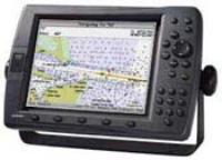
GPSMAP 547 |
Garmin |
Marine GPS |
2012 |
|
Description: Marine GPS Type: Chartplotter - Screen Size: 5" - Screen Type: LCD - Resolution: 480x640 - Memory Format (MSD): Micro SD - GPS Navigation Features: Tide Table, Track Log - Preloaded Map Coverage: United States (Coastal) - # of Waypoints: 5000 - I/O Interfaces: NMEA |
|
|
EchoMAP Plus 62cv |
Garmin |
Marine GPS |
2018 |
|
Description: Non Transducer Model. Marine GPS Type: Chartplotter - Screen Size: 6" - Screen Type: LCD - GPS Navigation Features: Tide Table, Track Log - Preloaded Map Coverage: United States (Coastal) - # of Waypoints: 5000 - Transducer Type: Dual Beam |

|
GPSMAP 6212 |
Garmin |
Marine GPS |
2010 |
|
Description: Marine GPS Type: Chartplotter - Screen Size: 12.1" - Resolution: 1024x768 - Memory Format (MSD): SD - GPS Navigation Features: External Antenna, Tide Table - Preloaded Map Coverage: Bahamas, United States (Coastal) - # of Waypoints: 5000 - I/O Interfaces: RCA, NMEA |

|
GPSMAP 2010C |
Garmin |
Marine GPS |
2001 |
|
Description: Marine GPS Type: Chartplotter - Screen Size: 10.4" - Screen Type: LCD - Resolution: 640x480 - GPS Navigation Features: Tide Table - Preloaded Map Coverage: United States |

|
GPSMAP 441 |
Garmin |
Marine GPS |
2009 |
|
Description: Marine GPS Type: Chartplotter - Screen Size: 4" - Resolution: 320x240, 240x320 - Memory Format (MSD): SD - GPS Navigation Features: Tide Table - Preloaded Map Coverage: Australia, Europe, Hawaii, South America, United States, United States (Coastal) - # of Waypoints: 3000 |

|
GPSMAP 431s |
Garmin |
Marine GPS |
2009 |
|
Description: Marine GPS Type: Chartplotter, Sonor - Screen Size: 4" - Resolution: 240x320, 320x240 - Memory Format (MSD): SD - GPS Navigation Features: Tide Table - Preloaded Map Coverage: Australia, Europe, South America, United States, United States (Lakes/Rivers) - # of Waypoints: 3000 - Transducer Type: Dual Beam |
|
|
EchoMAP CHIRP 45cv |
Garmin |
Marine GPS |
2016 |
|
Description: Marine GPS Type: Chartplotter, Fishfinder - Screen Size: 4.3" - Screen Type: LCD - Resolution: 480x272 - Memory Format (MSD): Micro SD - GPS Navigation Features: Tide Table - Preloaded Map Coverage: Canada - Depth Range (Feet): 2300 - Transducer Type: Dual Beam, Dual Frequency - Transducer Frequency: 77/200 kHz - I/O Interfaces: NMEA |
|
|
GPSMAP 741 |
Garmin |
Marine GPS |
2013 |
|
Description: Marine GPS Type: Chartplotter - Screen Size: 7" - Screen Type: LCD - Resolution: 800x480 - Memory Format (MSD): Micro SD - GPS Navigation Features: Track Log, Touchscreen, Tide Table - Preloaded Map Coverage: Worldwide - # of Waypoints: 5000 - I/O Interfaces: BNC, NMEA |

|
GPSMAP 2206 |
Garmin |
Marine GPS |
2006 |
|
Description: Marine GPS Type: Chartplotter - Screen Size: 6.4" - Screen Type: TFT LCD - GPS Navigation Features: 2D/3D Mapping |
|
|
EchoMAP CHIRP 72sv |
Garmin |
Marine GPS |
2015 |
|
Description: Transducer Model. Marine GPS Type: Chartplotter, Fishfinder - Screen Size: 7" - Screen Type: LCD - Resolution: 800x480 - Memory Format (MSD): Micro SD - GPS Navigation Features: Tide Table - Preloaded Map Coverage: Worldwide - Depth Range (Feet): 2300 - Transducer Type: Dual Beam, Dual Frequency - Transducer Frequency: 77/200 kHz - I/O Interfaces: NMEA |

|
GPSMAP 178 Sounder (Internal Antenna/Dual Frequency Transducer Version) |
Garmin |
Marine GPS |
2004 |
|
Description: Marine GPS Type: Chartplotter, Sonor - Screen Size: 7.5" - Screen Type: LCD - GPS Navigation Features: Tide Table, Built-In Antenna - Preloaded Map Coverage: Australia, Europe, South America, United States - Transducer Type: Dual Frequency - Transducer Wattage: 500 |
|
|
EchoMAP 50s |
Garmin |
Marine GPS |
2013 |
|
Description: Transducer Model. Marine GPS Type: Chartplotter, Fishfinder - Screen Size: 5" - Screen Type: LCD - Resolution: 480x640 - Memory Format (MSD): Micro SD - GPS Navigation Features: Thermometer, Track Log, Fish/Hunt Calculator, Touchscreen, Tide Table - Transducer Type: Dual Beam, Dual Frequency - I/O Interfaces: NMEA |
|
|
GMR 18 HD+ |
Garmin |
Marine GPS |
2016 |
|
Description: Marine GPS Type: Radar |

|
GPSMAP 225 |
Garmin |
Marine GPS |
2001 |
|
Description: Marine GPS Type: Chartplotter - Screen Size: 5.5" - Screen Type: LCD - Resolution: 320x240 - Battery Type: Li-Ion |

|
Fishfinder 160 |
Garmin |
Marine GPS |
2001 |
|
Description: Marine GPS Type: Sonor - Screen Size: 3" - Screen Type: LCD - GPS Navigation Features: Manual Zoom, Auto Zoom - Depth Range (Feet): 900 |
|
|
EchoMAP CHIRP 94sv |
Garmin |
Marine GPS |
2015 |
|
Description: Non Transducer Model. Marine GPS Type: Chartplotter, Fishfinder - Screen Size: 9" - Screen Type: LCD - Resolution: 800x480 - Memory Format (MSD): Micro SD - GPS Navigation Features: Tide Table - Preloaded Map Coverage: United States - Depth Range (Feet): 2300 - I/O Interfaces: NMEA |
|
|
GMR 18 xHD |
Garmin |
Marine GPS |
2013 |
|
Description: Marine GPS Type: Radar |
|
|
GPSMAP 4208 |
Garmin |
Marine GPS |
2007 |
|
Description: Marine GPS Type: Chartplotter - Screen Size: 8.4" - Resolution: 640x480 - Memory Format (MSD): SD - GPS Navigation Features: Tide Table - Preloaded Map Coverage: United States (Coastal) - # of Waypoints: 1500 |

|
GPSMAP 172C |
Garmin |
Marine GPS |
2004 |
|
Description: Marine GPS Type: Chartplotter - Screen Size: 4.5" - Screen Type: TFT LCD - GPS Navigation Features: Tide Table, External Antenna - Preloaded Map Coverage: United States - Transducer Frequency: 200 MHz |

|
Fishfinder 340C |
Garmin |
Marine GPS |
2006 |
|
Description: Marine GPS Type: Sonor - Screen Size: 5" - Screen Type: TFT LCD - GPS Navigation Features: Odometer - Depth Range (Feet): 1500 - Transducer Type: Dual Frequency |
|
|
EchoMAP 73dv |
Garmin |
Marine GPS |
2015 |
|
Description: Marine GPS Type: Chartplotter, Fishfinder - Screen Size: 7" - Screen Type: LCD - Resolution: 480x800 - Memory Format (MSD): Micro SD - GPS Navigation Features: Tide Table - Preloaded Map Coverage: United States - Depth Range (Feet): 2300 - # of Waypoints: 5000 - Transducer Type: Dual Frequency - Transducer Frequency: 50/200 kHz - Transducer Wattage: 500 - I/O Interfaces: NMEA |
|
|
GPSMAP 741xs |
Garmin |
Marine GPS |
2013 |
|
Description: Marine GPS Type: Chartplotter, Sonor - Screen Size: 7" - Screen Type: LCD - Resolution: 800x480 - Memory Format (MSD): Micro SD - GPS Navigation Features: Track Log, Tide Table, Touchscreen - Preloaded Map Coverage: Worldwide - # of Waypoints: 5000 - Transducer Type: Dual Beam, Dual Frequency - I/O Interfaces: BNC, NMEA |
|
|
EchoMAP CHIRP 42cv |
Garmin |
Marine GPS |
2016 |
|
Description: Non Transducer Model. Marine GPS Type: Chartplotter, Fishfinder - Screen Size: 4.3" - Screen Type: LCD - Resolution: 480x272 - Memory Format (MSD): Micro SD - GPS Navigation Features: Tide Table - Preloaded Map Coverage: Worldwide - Depth Range (Feet): 2300 - I/O Interfaces: NMEA |
|
|
Striker 4dv |
Garmin |
Marine GPS |
2016 |
|
Description: Marine GPS Type: Fishfinder - Screen Size: 3.5" - Screen Type: LCD - Resolution: 480x320 - GPS Navigation Features: Split Screen, Thermometer, Fish Identifier - Depth Range (Feet): 1750 - Transducer Type: Dual Beam, Dual Frequency - Transducer Frequency: 50/200 kHz - Transducer Wattage: 300 |
|
|
EchoMAP 94sv |
Garmin |
Marine GPS |
2015 |
|
Description: Transducer Model. Marine GPS Type: Chartplotter, Fishfinder - Screen Size: 9" - Screen Type: LCD - Resolution: 480x800 - Memory Format (MSD): Micro SD - GPS Navigation Features: Tide Table - Preloaded Map Coverage: United States - Depth Range (Feet): 2300 - Transducer Frequency: 50/200 kHz - Transducer Wattage: 500 - I/O Interfaces: NMEA |
|
|
EchoMAP Plus 95sv |
Garmin |
Marine GPS |
2018 |
|
Description: Non Transducer Model. Marine GPS Type: Chartplotter - Screen Size: 9" - Screen Type: LCD - GPS Navigation Features: Track Log, Tide Table - Preloaded Map Coverage: United States (Coastal) - # of Waypoints: 5000 - Transducer Type: Dual Beam, Dual Frequency - Transducer Frequency: 50/200 kHz |
|
|
GPSMAP 7610 |
Garmin |
Marine GPS |
2015 |
|
Description: Marine GPS Type: Chartplotter - Screen Size: 10" - Screen Type: LCD - Resolution: 1280x800 - GPS Navigation Features: Built-In Antenna, Track Log - # of Waypoints: 5000 - Transducer Frequency: 50/200 kHz - I/O Interfaces: NMEA, Component, DVI |
|
|
EchoMAP Plus 63cv |
Garmin |
Marine GPS |
2018 |
|
Description: Marine GPS Type: Chartplotter - Screen Size: 6" - Screen Type: LCD - GPS Navigation Features: Track Log, Tide Table - Preloaded Map Coverage: United States (Coastal) - # of Waypoints: 5000 - Transducer Type: Dual Beam, Dual Frequency - Transducer Frequency: 50/200 kHz |
|
|
GPSMAP 740s |
Garmin |
Marine GPS |
2010 |
|
Description: Marine GPS Type: Chartplotter, Sonor - Screen Size: 7" - Resolution: 800x480 - Memory Format (MSD): SD - GPS Navigation Features: Touchscreen, Tide Table - Preloaded Map Coverage: Bahamas, United States (Coastal) - # of Waypoints: 3000 |
|
|
GPSMAP 922xs |
Garmin |
Marine GPS |
2016 |
|
Description: Marine GPS Type: Chartplotter, Sonor - Screen Size: 9" - Screen Type: LCD - Resolution: 1024x600 - Memory Format (MSD): Micro SD - GPS Navigation Features: Touchscreen, Tide Table - Preloaded Map Coverage: United States (Coastal), United States (Lakes/Rivers) - Depth Range (Feet): 5000 - Transducer Type: Dual Beam, Dual Frequency - Transducer Frequency: 77/200 kHz - I/O Interfaces: NMEA, BNC |

|
GPSMAP 526 |
Garmin |
Marine GPS |
2009 |
|
Description: Marine GPS Type: Chartplotter - Screen Size: 5" - Resolution: 480x640, 640x480 - Memory Format (MSD): SD - GPS Navigation Features: Tide Table - Preloaded Map Coverage: Australia, Europe, South America, United States - # of Waypoints: 3000 |
|
|
EchoMAP Plus 95sv |
Garmin |
Marine GPS |
2018 |
|
Description: Transducer Model Marine GPS Type: Chartplotter - Screen Size: 9" - Screen Type: LCD - GPS Navigation Features: Tide Table, Track Log - Preloaded Map Coverage: United States (Coastal) - # of Waypoints: 5000 - Transducer Type: Dual Beam, Dual Frequency - Transducer Frequency: 50/200 kHz |

|
GPSMAP 276C |
Garmin |
Marine GPS |
2005 |
|
Description: Marine GPS Type: Chartplotter - Screen Size: 3.8" - Screen Type: LCD - Resolution: 480x240 - GPS Navigation Features: Built-In Antenna - I/O Interfaces: USB, Serial |
|
|
EchoMAP CHIRP 44cv |
Garmin |
Marine GPS |
2016 |
|
Description: Marine GPS Type: Chartplotter, Fishfinder - Screen Size: 4.3" - Screen Type: LCD - Resolution: 480x272 - Memory Format (MSD): Micro SD - GPS Navigation Features: Tide Table - Preloaded Map Coverage: United States (Coastal) - Depth Range (Feet): 2300 - Transducer Type: Dual Beam, Dual Frequency - Transducer Frequency: 77/200 kHz - I/O Interfaces: NMEA |

|
GPSMAP 178 Sounder (Internal Antenna/Single Frequency Transducer Version) |
Garmin |
Marine GPS |
2004 |
|
Description: Marine GPS Type: Chartplotter, Sonor - Screen Size: 7.5" - Screen Type: LCD - GPS Navigation Features: Tide Table, Built-In Antenna - Preloaded Map Coverage: Australia, Europe, South America, United States - Transducer Type: Single Frequency - Transducer Wattage: 400 |
|
|
EchoMAP CHIRP 53cv |
Garmin |
Marine GPS |
2016 |
|
Description: Marine GPS Type: Chartplotter, Fishfinder - Screen Size: 5" - Screen Type: LCD - Resolution: 480x480 - Memory Format (MSD): Micro SD - GPS Navigation Features: Tide Table - Preloaded Map Coverage: United States (Coastal) - Depth Range (Feet): 2300 - Transducer Type: Dual Beam, Dual Frequency - Transducer Frequency: 77/200 kHz - I/O Interfaces: NMEA |
|
|
EchoMAP CHIRP 92sv |
Garmin |
Marine GPS |
2015 |
|
Description: Transducer Model. Marine GPS Type: Chartplotter, Fishfinder - Screen Size: 9" - Screen Type: LCD - Resolution: 800x480 - Memory Format (MSD): Micro SD - GPS Navigation Features: Tide Table - Preloaded Map Coverage: United States - Depth Range (Feet): 2300 - Transducer Type: Dual Beam, Dual Frequency - Transducer Frequency: 77/200 kHz - I/O Interfaces: NMEA |

|
GPSMAP 210 |
Garmin |
Marine GPS |
1994 |
|
Description: Marine GPS Type: Chartplotter - Resolution: 320x240 - # of Waypoints: 500 |

|
GPSMAP 5215 |
Garmin |
Marine GPS |
2008 |
|
Description: Marine GPS Type: Chartplotter - Screen Size: 15" - Resolution: 1024x768 - GPS Navigation Features: Tide Table, External Antenna, Touchscreen - Preloaded Map Coverage: Bahamas, United States (Coastal) - I/O Interfaces: NMEA, RCA |
|
|
EchoMAP 70s |
Garmin |
Marine GPS |
2013 |
|
Description: Non Transducer Model. Marine GPS Type: Chartplotter, Fishfinder - Screen Size: 7" - Screen Type: LCD - Resolution: 800x480 - Memory Format (MSD): Micro SD - GPS Navigation Features: Tide Table, Thermometer, Fish/Hunt Calculator, Touchscreen, Track Log - I/O Interfaces: NMEA |
|
|
GPSMAP 7408 |
Garmin |
Marine GPS |
2014 |
|
Description: Memory Format: SD - Marine GPS Type: Chartplotter, Sonor - Screen Size: 8" - Screen Type: LCD - Resolution: 1024x600 - GPS Navigation Features: Touchscreen, Tide Table - Depth Range (Feet): 5000 - Transducer Type: Dual Beam, Dual Frequency - Transducer Frequency: 50/200 kHz - I/O Interfaces: NMEA, Composite, DVI |
|
|
EchoMAP CHIRP 75sv |
Garmin |
Marine GPS |
2015 |
|
Description: Marine GPS Type: Chartplotter, Fishfinder - Screen Size: 7" - Screen Type: LCD - Resolution: 800x480 - Memory Format (MSD): Micro SD - GPS Navigation Features: Tide Table - Preloaded Map Coverage: United States (Coastal) - Depth Range (Feet): 2300 - Transducer Type: Dual Beam, Dual Frequency - Transducer Frequency: 50/200 kHz - I/O Interfaces: NMEA |

|
GPSMAP 7215 |
Garmin |
Marine GPS |
2010 |
|
Description: Marine GPS Type: Chartplotter - Screen Size: 15.1" - Screen Type: TFT LCD - Resolution: 1024x768 - GPS Navigation Features: 2D/3D Mapping, Fish/Hunt Calculator, Sunset/Sunrise Calculator, Tide Table, Touchscreen, Track Log, External Antenna - # of Waypoints: 5000 - I/O Interfaces: RCA, NMEA |

|
GPSMAP 5015 |
Garmin |
Marine GPS |
2008 |
|
Description: Marine GPS Type: Chartplotter - Screen Size: 12" - Resolution: 1024x768 - GPS Navigation Features: External Antenna, Touchscreen, Tide Table - I/O Interfaces: RCA, NMEA |
|
|
Echo 201dv |
Garmin |
Marine GPS |
2014 |
|
Description: Marine GPS Type: Sonor - Screen Size: 5" - Screen Type: LCD - Resolution: 320x480 - GPS Navigation Features: Fish Identifier, Track Log, Split Screen, Thermometer - Depth Range (Feet): 2300 - Transducer Type: Dual Beam, Dual Frequency |
|
|
GPSMAP 721xs |
Garmin |
Marine GPS |
2013 |
|
Description: Marine GPS Type: Chartplotter, Sonor - Screen Size: 7" - Screen Type: LCD - Resolution: 800x480 - Memory Format (MSD): Micro SD - GPS Navigation Features: Touchscreen, Tide Table, Track Log - Preloaded Map Coverage: Worldwide - # of Waypoints: 5000 - Transducer Type: Dual Beam, Dual Frequency - I/O Interfaces: BNC, NMEA |

|
GPSMAP 531 |
Garmin |
Marine GPS |
2009 |
|
Description: Marine GPS Type: Chartplotter - Screen Size: 5" - Resolution: 320x240, 234x320 - Memory Format (MSD): SD - GPS Navigation Features: Tide Table - Preloaded Map Coverage: Australia, Europe, South America, United States, United States (Lakes/Rivers) - # of Waypoints: 3000 |
|
|
GPSMAP 525s |
Garmin |
Marine GPS |
2006 |
|
Description: Marine GPS Type: Chartplotter, Sonor - Screen Size: 5" - Resolution: 480x640, 640x480 - Memory Format (MSD): SD - GPS Navigation Features: Tide Table - Preloaded Map Coverage: Australia, Europe, Hawaii, South America, United States, United States (Coastal) - # of Waypoints: 1500 - Transducer Type: Dual Frequency |
|
|
GPSMAP 545 |
Garmin |
Marine GPS |
2006 |
|
Description: Marine GPS Type: Chartplotter - Screen Size: 5" - Resolution: 480x640, 640x480 - Memory Format (MSD): SD - GPS Navigation Features: Tide Table - Preloaded Map Coverage: Australia, Europe, South America, United States, United States (Coastal) - # of Waypoints: 1500 |

|
Fishfinder 400C |
Garmin |
Marine GPS |
2007 |
|
Description: Dual Frequency Transducer Model. Marine GPS Type: Sonor - Screen Size: 4" - Resolution: 320x240 - GPS Navigation Features: Fish Identifier - Depth Range (Feet): 1500 - Transducer Type: Dual Frequency - Transducer Wattage: 500 |

 Home
Home


 Car Stereo